Unearthed · Mount Aspiring & Mt Maunganui Nepal 2026
Mardi Himal Trek
21–30 September 2026 · Nayapul → Poon Hill → Mardi Himal Base Camp · 10 walking days
Itinerary changed. From Day 5 (25 September) the group is walking the Mardi Himal trek instead of continuing to Annapurna Base Camp. Days 1–4 are unchanged. See the original Annapurna Sanctuary plan →
Original itinerary (PDF) All GPX files (zip)
Now in Nepal — (NPT, UTC+5:45)
Trek days
Mon 21 Sep · trip day 4
Day 1: Nayapul to Ulleri
10.6 km · +1190 / −180 m
Tue 22 Sep · trip day 5
Day 2: Ulleri to Ghorepani
7.8 km · +970 / −140 m
Wed 23 Sep · trip day 6
Day 3: Ghorepani - Poon Hill - Tadapani
11.0 km · +900 / −1090 m
Thu 24 Sep · trip day 7
Day 4 · 3 options
A Tadapani to Chhomrong — 9.4 km, +500 / −1180 m
B Tadapani to Chhomrong via Komrong Danda — 11.0 km, +600 / −1290 m
C Tadapani to Chhomrong via Komrong Danda and Samrung — 11.0 km, +730 / −1420 m
Fri 25 Sep · trip day 8
Day 5: Chhomrong to Landruk
8.3 km · +640 / −1000 m
Sat 26 Sep · trip day 9
Day 6: Landruk to Forest Camp
3.7 km · +960 / −160 m
Sun 27 Sep · trip day 10
Day 7 · 2 options
A Forest Camp to Badal Danda — 5.0 km, +830 / 0 m
B Forest Camp to High Camp — 7.6 km, +1110 / −20 m
Mon 28 Sep · trip day 11
Day 8 · 2 options
A Badal Danda - Mardi Himal Base Camp - High Camp — 14.3 km, +1250 / −980 m
B High Camp - Mardi Himal Base Camp - Badal Danda — 14.3 km, +990 / −1250 m
Tue 29 Sep · trip day 12
Day 9 · 2 options
A High Camp to Siding — 8.2 km, +60 / −1740 m
B Badal Danda to Pittam Deurali — 13.2 km, +200 / −1340 m
Wed 30 Sep · trip day 13
Day 10 · 2 options
A Siding to Pokhara — 35.1 km, +520 / −1600 m
B Pittam Deurali to Kande — 5.6 km, +140 / −540 m
| Trek day | Trip day | Date | Route | km | Gain m | Loss m | Start → end m | PDF time | |
|---|---|---|---|---|---|---|---|---|---|
| 1 | 4 | Mon 21 Sep | Nayapul to Ulleri | 10.6 | +1190 | −180 | 1030 → 2047 | 4–5 h | GPX |
| 2 | 5 | Tue 22 Sep | Ulleri to Ghorepani | 7.8 | +970 | −140 | 2047 → 2877 | 5–6 h | GPX |
| 3 | 6 | Wed 23 Sep | Ghorepani - Poon Hill - Tadapani | 11.0 | +900 | −1090 | 2877 → 2688 | 6–7 h | GPX |
| 4 | 7 | Thu 24 Sep | Tadapani to Chhomrong | 9.4 | +500 | −1180 | 2688 → 2000 | 5–6 h | GPX |
| 4b | 7 | Thu 24 Sep | Tadapani to Chhomrong via Komrong Danda | 11.0 | +600 | −1290 | 2688 → 2000 | 5–6 h | GPX |
| 4c | 7 | Thu 24 Sep | Tadapani to Chhomrong via Komrong Danda and Samrung | 11.0 | +730 | −1420 | 2688 → 2000 | 5–6 h | GPX |
| 5 | 8 | Fri 25 Sep | Chhomrong to Landruk | 8.3 | +640 | −1000 | 2000 → 1640 | GPX | |
| 6 | 9 | Sat 26 Sep | Landruk to Forest Camp | 3.7 | +960 | −160 | 1640 → 2442 | GPX | |
| 7a | 10 | Sun 27 Sep | Forest Camp to Badal Danda | 5.0 | +830 | 0 | 2442 → 3268 | GPX | |
| 7b | 10 | Sun 27 Sep | Forest Camp to High Camp | 7.6 | +1110 | −20 | 2442 → 3534 | GPX | |
| 8a | 11 | Mon 28 Sep | Badal Danda - Mardi Himal Base Camp - High Camp | 14.3 | +1250 | −980 | 3268 → 3534 | GPX | |
| 8b | 11 | Mon 28 Sep | High Camp - Mardi Himal Base Camp - Badal Danda | 14.3 | +990 | −1250 | 3534 → 3268 | GPX | |
| 9a | 12 | Tue 29 Sep | High Camp to Siding | 8.2 | +60 | −1740 | 3534 → 1852 | GPX | |
| 9b | 12 | Tue 29 Sep | Badal Danda to Pittam Deurali | 13.2 | +200 | −1340 | 3268 → 2131 | GPX | |
| 10a | 13 | Wed 30 Sep | Siding to Pokhara (by road) | 35.1 | +520 | −1600 | 1893 → 805 | GPX | |
| 10b | 13 | Wed 30 Sep | Pittam Deurali to Kande | 5.6 | +140 | −540 | 2131 → 1729 | GPX |
Option A: 78 km on foot, +7300 / −6470 m, plus a 35 km jeep transfer on Day 10. Option B: 92 km on foot, +7600 / −6900 m, walking out to the road at Kande. Distances and gain/loss are computed from the GPX tracks (routed over OpenStreetMap trails; elevations from the Copernicus GLO-30 DEM), so they will not match a guide's figures exactly. Days 4b and 4c are alternative ridge routes for Day 4.
Overview map
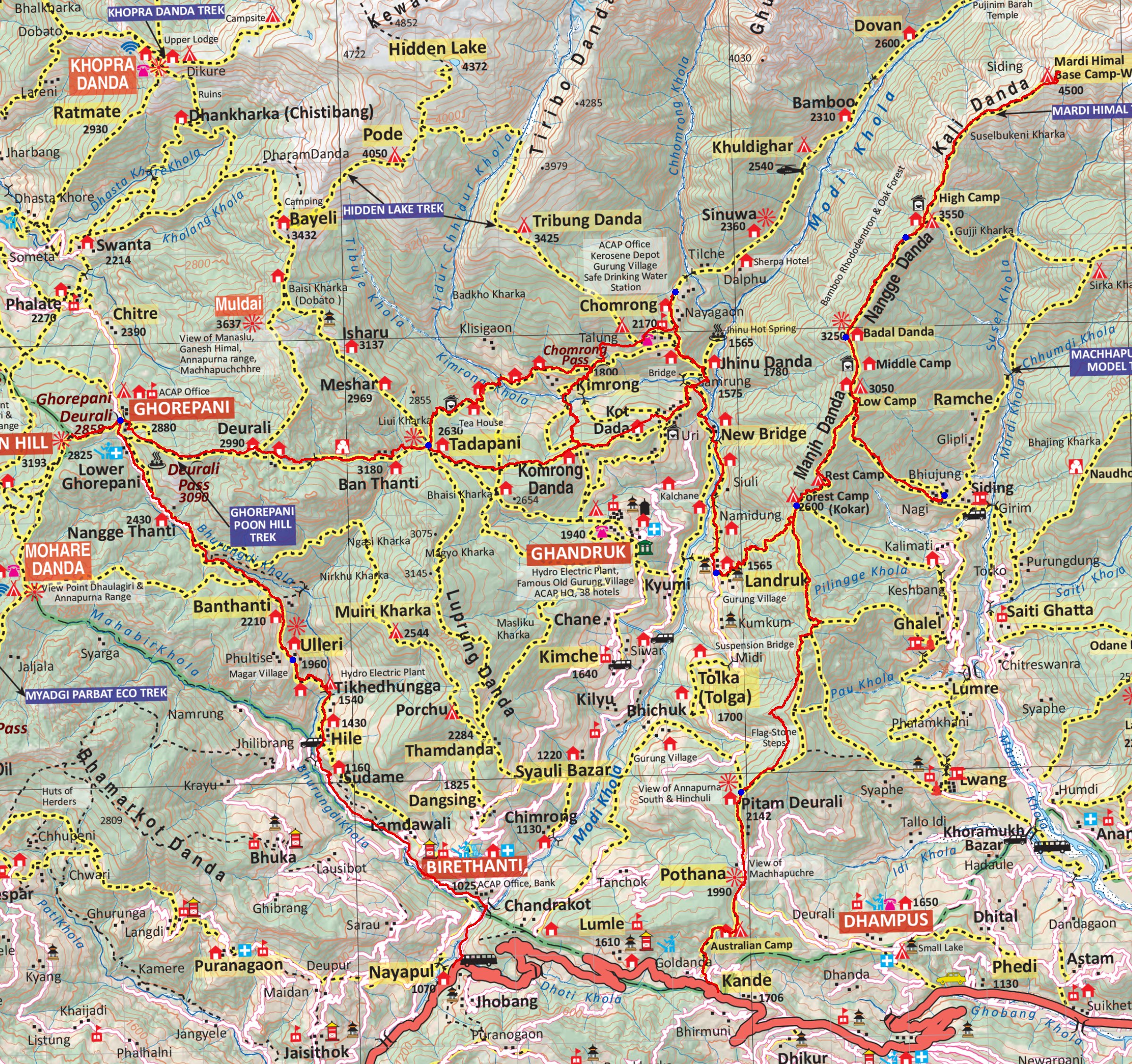
Before the trek
| Day | Date | Programme | |
|---|---|---|---|
| 1 | Fri 18 Sep | Arrive Kathmandu | Ground Team meets the group at Tribhuvan International Airport; transfer to the hotel and settle in. |
| 2 | Sat 19 Sep | Kathmandu heritage | Swayambhunath (Monkey Temple) and Boudhanath Stupa; local markets, money exchange, last gear. |
| 3 | Sun 20 Sep | Fly to Pokhara | Morning flight Kathmandu → Pokhara; Hotel Karuna, Lakeside. Afternoon trek briefing with the guides. |
After the trek
| Day | Date | Programme | |
|---|---|---|---|
| 14 | Thu 1 Oct | Pokhara rest day | Recovery day: boat rides, cafés, markets and viewpoints. |
| 15 | Fri 2 Oct | Rural school | Travel to a rural school outside Pokhara; community orientation, simple accommodation. |
| 16 | Sat 3 Oct | Community project 1 | Painting classrooms, light plastering, construction support, outdoor learning areas. |
| 17 | Sun 4 Oct | Community project 2 | Continued renovation work and cultural exchange with students. |
| 18 | Mon 5 Oct | Project completion | Finish the work, games with the students, farewell to the community. |
| 19 | Tue 6 Oct | Fly to Kathmandu, Bhaktapur | Flight Pokhara → Kathmandu; drive to Bhaktapur, evening walk in the old city. |
| 20 | Wed 7 Oct | Bhaktapur | Durbar Square, Taumadhi Square, artisans; hands-on pottery lesson in Pottery Square. |
| 21 | Thu 8 Oct | Return to Kathmandu | ~2 h drive; final city time, group reflection, final dinner with optional Nepali cooking class. |
| 22 | Fri 9 Oct | Depart | Transfer to Tribhuvan International Airport for the flight home to New Zealand. |
Sources
- Itinerary: Unearthed Education, Nepal MAC&MMC Itinerary (PDF). The revised Mardi Himal days are not covered by the PDF.
- Routes: © OpenStreetMap contributors (ODbL), routed between the itinerary's villages along mapped trails.
- Elevations: Copernicus DEM GLO-30 (© DLR e.V. 2010–2014 and © Airbus Defence and Space GmbH 2014–2018, provided under COPERNICUS by the European Union and ESA).
- Maps: NP107 Annapurna, Naar & Phu (Himalayan Map House); 1:50,000 topographic sheets 2883/2884 (Survey Department, Government of Nepal / FINNMAP), georeferenced in this project.